|
Struve triangulatsiooni ahela põhjapoolse osa kasutamine |
{ A. Veriö Geodeet 6(30) 2002 27-30 }
Later Phases and Utilizing of the Northern Part of the Struvean Chain
A. Veriö
Finland, National Land Survey of Finland, National Board of Survey, Pasila Office Centre, Opastinsilta 12 C, P.O. Box 84 SF-00521 Helsinki
Vene-Skandinaavia triangulatsiooni mõõtmine oli korraldatud nii, et Vene Impeeriumi asutused vastutasid selle eest Mustast merest Botnia lahe põhjatipuni, Rootsi jätkas siit piki Tornio jõe orgu kuni Soome-Norra piirini ja Norra mõõtis selle triangulatsiooni ahela kõige põhjapoolsema osa. Struve triangulatsiooni punktidel oli suur tähtsus kaardistamise geodeetilise alusena nii Baltimaades kui ka Soomes. See oli ka lähtealuseks triangulatsioonivõrgu rajamisel üle kogu maa. Sama olukord oli ka Rootsis ja Norras. Sellega seoses taastati 19. sajandi viimastel aastakümnetel (1874-1895) Rootsis, Soomes ja Norras suur osa Struve triangulatsiooni punkte. Seda informatsiooni on täiendatud 1968 ja 1989 aastatel dr. Seppo Härmälä initsiatiivil organiseeritud ekspeditsioonide käigus. Et Struve triangulatsiooni ahela punktid omavad suurt teaduslikku ja kultuurilist väärtust, oleks vajalik nad võtta rahvusvahelise kaitse alla, lülitades nad UNESCO ülemaailmsete väärtuste nimekirja.
The Struvean Chain
One of the greatest and most magnificent attempts to investigate and define the size and shape of the Earth, was, in it's era, the Russo-Scandinavian triangulation, which was carried out in 1816-1852. It extended from the outlet of the Danube at the Black Sea to Fuglenes on the shore of the Arctic Ocean, and formed a continuous triangulation chain from 45°20'N to 70°40'N. In Finland, and also at least in the Balticum, it is shortly called the Struvean Chain after W. Struve, the leader of the campaign and the chief editor of the big publication "Arc du Meridien de 25° 20'“, dating from 1861, which is the final report of this international scientific investigation.
This paper deals mainly with the third part of the Chain situated within Finnish territory or used in the Finnish mapping.
As the official name of the network tells us, the chain was measured and calculated as an international cooperation. The work began from Latvia and Estonia by W. Strave in 1819-31. Struve was at that time professor of astronomy at Dorpat University where he graduated from at the age of 18 in 1811. The work was continued southwards under the responsibility of C.v. Tenner, and northwards under the leading of Struve. The Swedes carried out the work along the river Tornio in Lapland up to the Finnish-Norwegian border, and the Norwegian part of the chain consisted of the 12 northernmost triangles and one baseline.
The leader of the Swedish part was prof. Selander and the Norwegian part was led by prof. Hansteen. Typically for this multinational effort, the reconnaissance and observations were entrusted to local experts, e.g. in Finland the majority of observations were made by F.Woldstedt, later professor at Helsinki University.
The construction of the chain
The total length of the triangulation is 2880 km. It is, for the most part, a single triangulation chain, only the Swedish part has some and the Norwegian part several extra diagonal. However, there is one exception in the chain: Hogland, in the middle of the Gulf of Finland, forms a one-point joint which divides the chain in to the northern and southern parts. Hogland is also one of the 13 astronomic stations.
The number of baselines was 10, and four of them were situated in the northern half of the chain. The accuracy of observations stands comparison with many current nets: Ferrero's formula gives +0.18 mgon one direction.
The purpose of measuring the chain was scientific (and in addition, in a spirit of rivalry, to create the longest triangulation chain in the world). The importance of this great work as the basis for future mapping seemed to be fully in the background. The careful documentation of the stations arose from the need to control the immobility of the signals during the relatively long observation time of the chain.
The documentation situation was perhaps best in the part between Hogland and Tornio. Nearly all stations were marked with small copper plates, which were soldered with lead into 5-7 cm deep boreholes drilled in the rock or big stones.
The practical use of the chain
The creating of the chain, from reconnaissance to the last observation, lasted in Finland for over twenty years, 1830-1851. At the same time, there was the normal struggle to improve the mapping situation of the country.
Large-scaled maps (1:8000 and 1:20 000) were local by nature, and a decision to compile a new general map in the scale of 1:400 000 was given in the 1840's. All astronomical observations made in the country were collected for the ground control. Only a few Struvean stations were used in the southern part of Finland, because there were quite a lot of astronomical determinations. The priority, according to conceptions of those days, is reflected in the fact that in Lapland Struvean stations were used at full capacity because the astronomical stations were few and far between.
In the 19th century, topographical maps were regarded as military affairs and the administrative distinction between military and other work was clear. The Topographic Corps immediately made use of the stations of the Struvean chain, e.g. at Murtomäki the local mapping began from the station when the wooden signal was still standing in its place. In the 19th century, the largest triangulation net with the Struvean chain as the initial extended to the Gulf of Bothnia and covered 36 000 sq.km.
The trigonometric height determination of the chain was of great importance, because levellings, at that time, were concentrated primarily along river valleys.
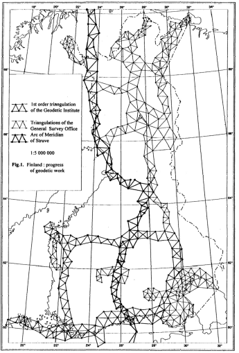
The systematic triangulation of Lapland begun in all three countries during the second half of the 19th century and the Struvean chain served as the backbone. These activities extended far to our century. Fig. 1 presents the situation in northern Finland in 1931.
Fig. 1
As late as 1936 one part of the Struvean chain was calculated into the then prevailing mapping coordinate system in the middle of Finland. We can hereby demonstrate that the Struvean chain was utilized around 100 years in mapping.
There is one more unmentioned usage for the center marks of the chain, and this application is not included in geodesy or cartography. In the last century, the original lead in the boreholes was dug out and prepared into hunting bullets.
Expeditions to find the Struvean stations
As was said before, nearly all stations in Lapland were in use from the very beginning, and if the documentation was inadequate the situation was remedied immediately.
A real systematic search was carried out in 1886, 1888 and 1889 by Alfred Petrelius, later professor at the Technical University, Helsinki. He did his exploration in the last minute, because traditions, concerning the measuring campaign itself, were still alive. He searched the stations from the southern coast of Finland up to the farthest corner of the Bothnian Bay. This part of the net consists of 71 main stations in total. Eight of them were not marked on the ground, and from the remaining 63 he found 51 (81%). He built up small pyramides of stones above the centres of the stations and made descriptions of the surroundings.
In connection with newer triangulation, a lot of Struvean stations have been tied to fixpoints of the present net during the time. This information was supplemented by expeditions in 1968 and 1989 on the initiative of Dr. Seppo Härmälä, former deputy general director of National Board of Survey.
The number of Struvean main stations within Finnish territory, including those which have been used in the mapping of Finland, was 92 in total. Eight of them were undocumented, and 61 (73%) of the remaining 84 were found, 18 were stated to be destroyed (21 %) and the fate of 5 is unknown.
Other historical aspects
We can say that the history of Struvean chain has come full circle. The great work began in the atmosphere of the academic scientific spirit: to find out better dimensions for the Earth. The last expeditions to sort out the present situation of the stations was also entirely of neutral historical importance: to preserve one document of past generations' work and international cooperation. The interval of these past 150 years has included a big quantity of practical utilization, with relevant scientific and administrative politics, too.
We can state that these modest holes in the rock are valuable relics, archaeological documents. In our neighbouring countries, there are some better visible monuments. The big statue at Fuglenes in Norway is famous. In Estonia, the Struvean stations and the impressive end of the Simuna baseline are nearly places of pilgrimage among land surveyors.
The Struvean expedition left its marks in Finnish place names, like (translated) Telescope Hill, Plane Table Top, Stone Pile Top. For the geodesists and land surveyors of our days, too, the expedition has an useful message: the importance of good documentation and descriptions of ground control points.
References
1. Struve, F.G.W. 1860, Arc du Méridien de 25°20' entre le Danube et la Mer Glaciale. St. Pétersbourg.
2. Donner, A., Petrelius, A. 1889, Das Aufsuchen von Dreieckpunkten in Finland. Fennia I No 4, Helsinki.
3. Gustafsson, A. 1933, Mapping activities after 1809 (in Finnish). The History of Land Surveying in Finland II. Porvoo.
4. Järnefelt, A.A. 1901, Astronomisch-geodätische Arbeiten in Finnland vom Jahre 1865 bis 1875. Fennia 10 No 1, Helsinki.
5. Jäämaa, 0. 1930, The part from Tornio to Beljashvaara of the Russo-Scandinavian triangulation chain (in Finnish). Publ. of National Board of Survey No 17, Helsinki.
6. Kukkur, K. 1989, W. Struve (1793-1864) as geodesist (in Estonian). Manuscript.
7. Mannermaa, K.H. 1914, Searching of stations of the Russo- Scandinavian triangulation north of Tornio (in Finnish). Maanmittariyhdistyksen aikakausikirja, Helsinki.
8. Mathisen, O. 1970, The new 1. order's net in Northern Norway (in Norwegian). Proceedings of the 6th general meeting of the Nordic Geodetic Commission, Helsinki.
9. Nickul, K. 1930, The transverse chain of Kittilä (in Finnish). Publ. of National Board of Survey No 17, Helsinki.
10. Petrelius, A. 1890, The search for triangulation stations in Finland in 1889 (in Swedish). Fennia 3 No 12, Helsinki.
11. Rainesalo, A. 1928, The triangulation chain Kajaani-Kemijärvi-Tornio (in Finnish). Publ. of National Board of Survey No 15, Helsinki.
12. Rainesalo, A. 1949, Über die Höhenbestimmungen der Russish-Scandinavischen Gradmessung. Publ. Finn. Geod. Inst. No 36, Helsinki.
13. Veriö, A. 1970, The Struvean triangulation stations today (in Swedish). Proceedings of the 6th general meeting of the Nordic Geodetic Commission, Helsinki.
14. Zelnin, G., Vallner, L. 1984, W. Struve as geodesist (in Estonian). Tähetorni Kalender, Tartu. 15.The archives of National Board of Survey, Helsinki.