|
Rootsi, prantsuse ja vene traditsiooni mõju eesti kartograafiale |
{ J. Lankots Geodeet 6(30) 1994 10-11 }
The Influence of Swedish, French and Russian Traditions on Estonian Cartography
J. Lankots
Estonian Agricultural University, Kreutzwaldi 5, Tartu, EE2400, Estonia
Rootsi mõju eesti kartograafiale on tuntav rootsi maamõõtjate poolt rootsi ajal aastail 1684-1710 Eesti kohta valmistatud tuhandete suures mõõtkavas kaartide kaudu, mida praegu säilitatakse Eestis. Prantsuse edu märke maakera suuruse ja kuju määramises 18. sajandil leidub tolleaegsete vastavate raamatute kujul Tartu Ülikooli raamatukogus. Prantsuse mõju ulatub Eesti kartograafiasse peamiselt Vene kaudu, kus töötas prantslane J.N. Delisle (Struve-eelse triangulatsiooni katsetaja), võeti käsutusele R. Bonne'i projektsioon (selles projektsioonis on Eesti ala kaart 24 lehel mõõtkavas 1:126000, valmistatud aastail 1855-1859), tõlgiti N.A. Tissot (moonutuste ellipsi autori) raamat. Baltisaksa mõju hõlmas kõiki eluvaldkondi. Suur osa vanu kaarte on saksakeelsed. Vene mõju oli kestev ja korduv (1721-1917, 1940-1990), kuigi kaartide salastamisega tagasi hoitud.
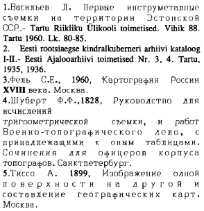
Since 1561 either the whole territory of Estonia or some of its parts belonged to Sweden during a century and a half. In the 1680's, the Swedish Government began to take estates into the state ownership and thus a need arose for estate maps. Swedish surveyors sent to Estonia made thousands of large-scale maps here (1). A large number of these maps are now in Estonia and their lists have been published in special reference books (2). At the beginning of the 19th century the Russian War Minister repeatedly demanded that the Swedish maps of Estonia should be transformed to St.Petersburg from Riga where they were kept. If this had happened, the maps probably would have remained in Russia up to now. Instead, most of the maps eventually reached Estonia. Three generations of researchers have already had the possibility to study them. Results of the studies are available in scientific publications and textbooks.
The fact that the original maps made by the Swedes have been available for Estonian scientists is bringing Sweden and the Swedes nearer to Estonia and to the Estonians even now. A real and palpable proof inspires confidence, and the amount and the accuracy of the work of the Swedish surveyors evokes admiration. It is natural to interprete and evaluate the historic materials in the area where they have been drawn up.
In 1721 Sweden ceded Estonia to Russia. The Czar Peter I invited many foreign specialists to Russia. Among them was the French scientist Joseph Nicolas Delisle. Geodesy and cartography were well-developed in France at that time. Delisle carried out the first triangulation of Russia in 1737-1739 (3). (The second triangulation was carried out by F.G.W. Struve and Karl Tenner and the French influence on Russian geodesy and cartography continued up to the 20th century). The French proved by triangulation Newton's statement that the Earth is slightly flattened at the poles. The projection conceived by the French engineer Rigobert Bonne was used on the military map of Russia. Its scale was 1:126000. It consisted of 726 sheets and its printing began in 1845. The territory of Estonia was mapped on 24 sheets in 1855-1859. The head of the Russian military topographic office F.F. Schubert wrote in his instructions to the military cartographers in 1826 (4) that only two types of projection should be used in making maps - Bonne's projection for land maps and Mercator's projection for sea maps.
The study of distortion indicatrice and map projections by Nicolas Auguste Tissot was published in Russian in 1899 (5). A representative collection of books written and published in France in the 18th century by those French scientists who had taken part in the measurements of the meridian arc can be found in Tartu University Library. These books treat the measurements of the meridian arc with the aim of determining the shape and the size of the Earth. Among these books is the German edition (1741) of "De la grandeur et de la figure de la terre" by J. Cassini (first published in Paris in 1720), "La figure de la terre" by M. Maupertuis (1738), the second printing (1808) of "Theorie de la figure de la terre" by A.-C. Clairaut (first published in 1743). "Methode pour lever les plans et les cartes" by J. Ozanam (1781) introduces the art of cartography. These books have, undoubtedly, inspired and encouraged the scientists of many countries to try to solve the problem of the exact size and shape of the Earth.
A large-scale map of France made in 18th century and based on triangulation and astronomical measurements served as a model for other countries.
Because those who used maps in Estonia, were mostly the Baltic-Germans, the majority of maps were in German language. The older maps, even those in Russian, mostly carry the germanized versions of place-names. The Baltic-Germans lived in Estonia from the 13th century until 1939, when they were forced to resettle in Germany.
The maps produced during Swedish period, but also large-scale maps of later periods, have not yet been cartographically studied. The images of the old maps should be superimposed onto modern maps in order to enable us to visually compare the past and the present. By putting together the images of the maps of different periods we can visualize the changes and developments of the territory. Unfortunately so far we do not possess any suitable technology for comparing old and new maps.
The French influence reached Estonia indirectly. It can be recognized through Russian tradition of mapping when we analyze the origin of cartography of the Estonian Republic (1918-1940). Russia ruled over Estonia twice (1721-1917 and 1940-1990). In Russian cartography the mathematical aspect is remarkably well-developed. The Russian maps have since 1812 been in the possession of the army. Because they were not available for the public, the influence of the Russian mapping tradition in Estonia remained limited.
References
